Dit zijn de afstanden die er per dag gefietst zijn. Dag 4 was de rustdag.Dag 5 en 6 waren de dagen dat we rond hebben gereden in de Veluwe zonder bagage.

BramTeunissen.com
France - Day 6 : How high is the Ventoux?
Today, the route would consist of 20 km of mountains followed by a long flat section. The local bakery, as usual, sold baguettes, flutes, and gros pains. Baguettes are just smaller French breads, flutes are twice as thick and much more airy and tasty. Gros pains are similar to flutes but broader. The bakery sold gros pains that were half a meter long and 30 cm wide. We bought one, which was handed to us in a bag roughly the size of Bram's bivy bag. After breakfast, we still had 2/3 left. It lasted until dinner.
From Romans-sur-Isere, we could race over straight roads. We had enough bread but no nothing to put on it. There were all sorts of shacks along the road selling fresh fruit directly off the land. I asked for a jam at one of them. They didn't sell that but did have some pasta. It was 6,10, which I thought was expensive. They also sold 'miel de fleurs', 'miel de lavande', 'miel of this', and 'miel of that'. I didn't know what 'miel' was, but we bought the cheapest version. It turned out to be honey and was really tasty.

Our road was flat, but we were getting closer to the Alps.
From Crest onwards, we really needed to climb. It was super hot and pretty, though. During the descent, we entered a valley that looked like Spain.

It was very hot in this valley.
To get out of the valley, we needed to climb again. It was a good training for the Mont Ventoux, which we could see for the first time.

Our first view of the Mont Ventoux
It was still about 50 km to the campsite on the other side of the Ventoux. We feared the way there would be pretty mountainous.

The Ventoux, with in front the hills we needed to cross to reach the campsite.
We decided to cut a few kilometers off our route on the descent. That meant we wouldn't pass a big city and couldn't buy any food or drinks. Fortunately, we found a pizzeria. We definitely had more luck finding food than last year. At least it seemed that way, the pizzas were only available in the early afternoon, so we still couldn't eat anything. We had no choice but to continue. It wasn't really flat there so that made cycling even worse. Grapes were growing along the road, but they weren't very tasty, probably because they were meant to make wine.
We also saw some plum and apple trees. We wanted to pick a few but then realized the people who owned the land were watching from 10 meters away. Fortunately, we could buy food from them. We bought Galia melons for 80 cents apiece. They were nice and juicy. In Nyons, we bought ravioli, water, and fruitcake. Bram had tried those in the past. They were delicious, about half of it was sugar, and the rest was garbage food.
The last section toward the Ventoux wasn't as hilly as we had feared. Outside of Nyons, we searched for a bench so we could eat. We couldn't find one, but Bram found a shady spot on the roadside. I proposed cycling a bit further, and Bram said, 'What are the odds there will be a bench a few minutes further?'. We both looked down the road, and there were three tables and six benches within 50 meters. There, we began cooking the ravioli. When the stove was on for one minute, it went out. Now, we were out of fuel, and the ravioli was only lukewarm. It wasn't really edible, but we had little choice.
The last climb before the campsite wasn't that bad, here is a picture from the summit.

The landscape at the foot of the Ventoux.
When I turned around, I started to laugh. After 180 km, this climb seemed easy, but then I saw this sign:
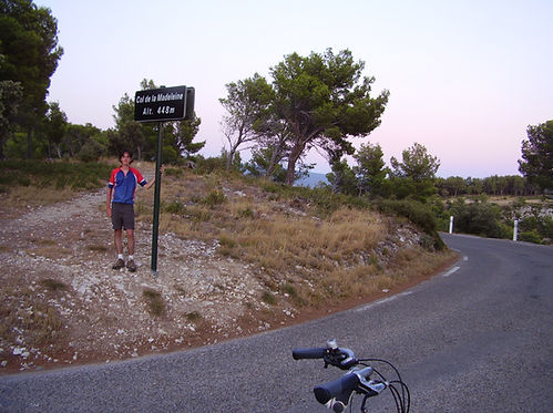
This col had the same name as a famous one that often makes it into the Tour de France.

We took a picture of each col to have some photos of ourselves.
We turned our lights on during the descent as it was getting dark. It was one continuous descent to Bedoin, where the climb to the Mont Ventoux starts. We would also camp there. We passed a different campsite than the one we were aiming for. It was completely full, and we hoped ours wasn't. After a few kilometers, we discovered we had been cycling in the wrong direction. It was about 22:30, and we had already cycled 180 km. Back in the village, we set out in a different direction, without being 100% sure that was the correct one. Luckily we found the campsite. There was a nice bar with personnel to show us a place to pitch our tent. We didn't shower because it was too late.

The hot valley lay between Crest and La-Begude-de-Mazenc. Just before Gringan, we took a shortcut.
Col de la Madeleine lies between Malaucene and Bedoin. It is also possible to climb the Ventoux from Malaucene.
Daily distance 188,19 km
Average speed 20 km/h