Dit zijn de afstanden die er per dag gefietst zijn. Dag 4 was de rustdag.Dag 5 en 6 waren de dagen dat we rond hebben gereden in de Veluwe zonder bagage.

BramTeunissen.com
South Greenland - Day 23 : Glaciers
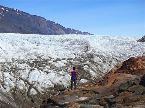
My last hike would be a short one of only 1,5 days. As I spent most of previous afternoon resting it felt like it was my first hike in a long time. Because there was an asphalt and gravel road I could walk fast for the first few kilometres. I passed two men along the way, which turned out to be the same as those I had met on the campsite in Igaliku. I kept going while they stopped to take photos. At some route the road went almost straight up to 300m elevation, but fortunately there were ropes to pull myself up. On top was a nice lake followed be a 300 meter descent to a glacier. The view was amazing. I could see the entire glacier and the icecap and mountains in the distance. I could also walk on the glacier.


By now the two Danish men had caught up with me. We took some photos of each other and had lunch. One of them worked for the Danish meteorological institute and had visited Narsarsuaq for work a few times before, but now was on vacation.


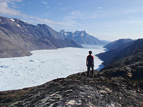
We spent a long time talking about my gear and all the places I had visited, so I got quite a bit behind schedule. Eventually we said goodbye and I had to climb back up the 300 meter high hill. From there followed another climb to 600 meters. I was now in an area called Mellemlandet (the middle country) which lies in between two glaciers. As there are no sheep the vegetation was quite different, with much taller grass and more flowers. The views were exceptionally nice and I wouldn't have mind spending a few more days there. Around 5 o'clock I reached my second stop of the day, a hill that overlooked the glacier to the east of Narsarsuaq. I left my backpack behind before starting the steep climb. At some places I again needed to use both my hands and feet to get up. The view was one of the best I had ever seen. The entire fjord was filled with icebergs and every few minutes I could hear and see parts calving off. I had read that the glacier produced about 200.000 metric tons of ice per year. I spent a long time trying to take a nice picture of myself. This wasn't easy because there were so many mosquitoes flying into view.


After taking a bunch of photos I went down again. I was super tired from the many days hiking, but fortunately the route would be easy from there on and this was my last real hike day. I did regret not having one day more, because then I would have been able to walk to the tip of Mellem landet, where both glaciers I had visited today merge and you can look out over the Greenland ice sheet. Along the way, I discovered someone camping. The guy told me he had planned to hike in Greenland for a few weeks, but his shoe sole had come loose on the first day. Therefore, he now just camped in one spot and did a few day trips. I couldn't image going to Greenland with shoes like that, and if it would happen I would probably have bought a large roll of duct tape and tried to fix them. I also passed an emergency cabin, but there was nobody there.


From there it was only 3 more kilometers through grassy fields to reach the rope descent and then another 2 hours to get back to the campsite.

